WCT’s FLOWIDER App Integrates Crucial Flood Data for Riverine Species Conservation and Flood Risk Management
River flooding keeps species, ecosystems, and societies living on floodplains alive and healthy by annually replenishing and recharging them with life-giving nutrients, sediments, and water. The annual rise and ebb in a river’s flow, driven by precipitation, is defined as the river’s ‘flood-pulse’. Not only does the survival of riverine wildlife and biodiversity depend on the river flood pulses and dry season flows, together referred to as a “River Wave”, but so does the survival of millions of people who are directly or indirectly dependent on the multitude of riverine ecosystem services such as soil fertility for agriculture, fishery yields, groundwater recharge, etc.
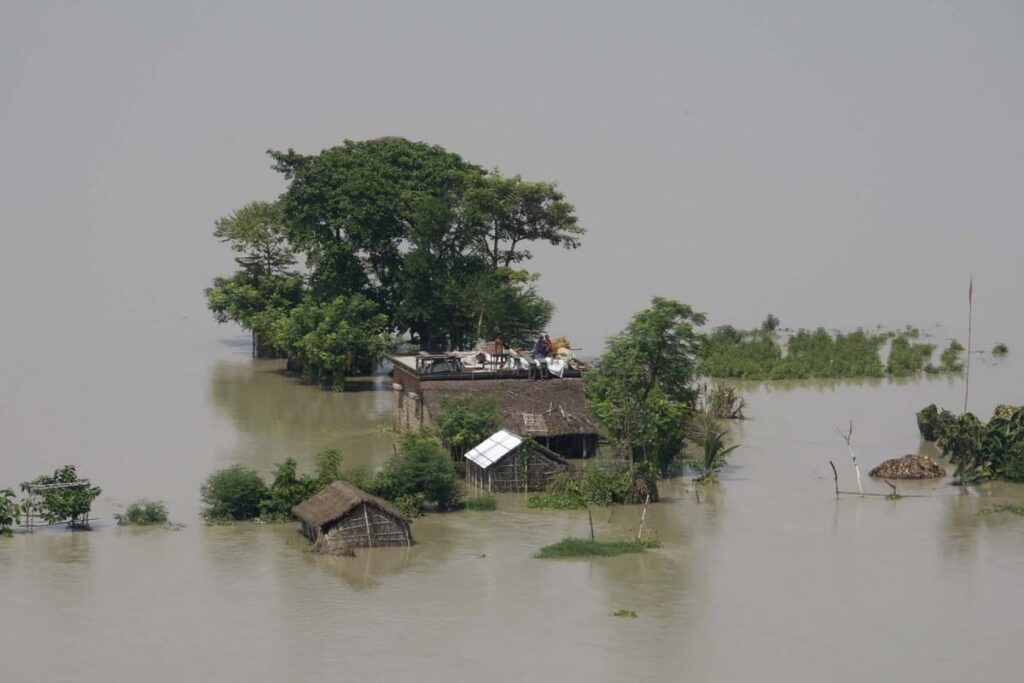
A scene from the Kosi River floods in Bihar last year. Effective flood-risk monitoring, and dam management requires rigorous analysis and planning to mitigate the worst impacts of flood-related disasters. ©Wikimedia Commons
All rivers need to flood as naturally as possible. However, anthropogenic impacts on river flows, climatic changes, or sometimes, tectonic activities can result in extreme flooding, which can also be disastrous for the society. Here, astute disaster management and flood risk monitoring become essential. For effective flood and dam management to safeguard threatened habitats and secure socio-economic benefits for communities, accessing and analysing past and present flood-season water level data is essential. This entails tracking flood-season water levels, identifying patterns, and making informed decisions.
Easy access to river flow water level data for such analyses is thus very important for researchers and other professionals working on freshwater ecosystems, threatened riverine species, and flooding-related environmental and social impacts.
Importance of Data Integration
India’s Gangetic plains are among the largest and most densely populated river floodplains anywhere in the world. Populations of several endangered and critically endangered riverine species such as the Ganges river dolphin, gharial, Indian Skimmer, Black-bellied Tern, and freshwater turtles are also found in this intricate network of river channels, tributaries, floodplains, wetlands, and deltas. The life cycles of these species, and livelihoods of people are both inextricably linked to floods.
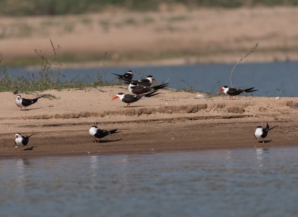
Some of the rivers in the Gangetic plains such as the Chambal harbours a significant breeding population of the endangered Indian skimmer, which typically nests in isolated sand islands in the summer, making it vulnerable to variations in river water levels. Photo credit: Dr. Anish Andheria
From June to October, which is normally the flood-season in the Gangetic plains, river water level data are made available in the public domain by state government water resource departments on their web portals with the objective of flood disaster risk management and as a warning system. But these important data are often scattered across multiple online sources and are also recorded in variable data structures and non-translatable formats. Easier access to these important datasets therefore becomes immensely valuable.
Recognising the real need for compiling and integrating flood-season water level data in one place for ease of access and analysis by scientists, students, conservationists, etc. the team of river ecologists at the Wildlife Conservation Trust (WCT) has developed a novel web-application called ‘Flow and Water Level Integrated Datasets for Ecological studies of Rivers’ or FLOWIDER 1.0., as part of WCT’s Riverine Ecosystems And Livelihoods (REAL) programme.
FLOWIDER 1.0
FLOWIDER 1.0 (pronounced as flow-y-der) is a user-friendly web-based application that provides a graphical interface to track flood-season water levels of 107 sites (gauging stations) across 24 rivers in the Gangetic plains spanning six Indian states. The FLOWIDER database has been painstakingly curated from publicly available flood level data across water resources department websites over the last decade.
“Daily flood-season water level data from June to October for each year were compiled from station-wise and day-wise datasets. All flood-level data from 2013 onwards were manually entered from PDF files or web pages that would be updated daily. All stations had one recorded water level value per day, and for barrage or dam sites, we manually recorded the downstream water level value corresponding to the first timestamp of the day when the data became available. For certain years and stations, only graphs of flood-season water levels were available in the form of flood reports. In such cases, we used digitising tools to directly extract data from the available graphs. All in all, data entry, cleaning and compilation involved a lot of work.” explains S. Ramya Roopa, Data Analyst with WCT, who developed the FLOWIDER 1.0 app .
As many as 1,00,400 flood-season water level data points were compiled for the period from 2010 to 2023. This enormous dataset forms the crux of the FLOWIDER 1.0 application.

The flood water level data accessed and analysed using the FLOWIDER 1.0 app can help monitor threatened riverine species across 24 rivers in the Gangetic Plains, such as the critically endangered gharial. Photo credit: Soumen Bakshi
“The novelty of the app comes from the interactive searches on the data with species, river, and date filters,” Ramya adds. The application has been thoughtfully designed to provide researchers with a viewing and exploration interface where they can filter data by station and selection of threatened wildlife species. Seven endangered or critically endangered species and animal groups have been used in the app for the species-based selection of river and gauging stations. These include the critically endangered gharial crocodile, the endangered Ganges river dolphin (India’s National Aquatic Animal) and Indian Skimmer, and other vulnerable or near-threatened species such as smooth-coated otter, marsh crocodile, other species of freshwater softshell and hard-shell turtles, and the Hilsa, a declining fish species.
Video demonstration of the FLOWIDER 1.0 web application. Credit: WCT
FLOWIDER 1.0 provides a map view of gauging stations and graphing options to explore flood water-level time-series of up to two stations simultaneously and features a searchable tool for users to access metadata on individual river stations.
From assessment of flood level rise and recession, and designing hydrological studies, to assessing impacts of dams and barrages or extreme rainfall events on flood-pulses, FLOWIDER 1.0 app has many valuable applications.
“I am very happy that our team’s hard work has resulted in this resource that can be potentially useful for many researchers. While data entry appears to many as a mundane and boring task, we did that diligently, with repeated checking and editing to reconfirm that all values in this large dataset were correct and as per the original source documents. In essence, we have done the hard work that can ease access to these data for researchers and policy makers. We thank the BNP Paribas India Foundation for their unflinching support.”, says Dr. Nachiket Kelkar, who heads the REAL programme at WCT.
WCT’s end goal for the app is to help diverse users get relevant information on flood water levels at one place. The REAL programme team has been working in the Gangetic plains for a long time, and hence this region was the obvious inaugural choice of focus for them in the creation of this app. However, as per the need and data gaps, the REAL team aims to extend the FLOWIDER app to other rivers in northern and eastern India. The team also plans to add new features to the app in due course, which will enable better utilisation of available datasets for various studies and monitoring exercises in river eco-hydrology and water management.
App resource links:
A video demonstrating how to use the FLOWIDER app can be watched here.
About the author: Purva Variyar is a conservationist, science communicator and conservation writer. She works with the Wildlife Conservation Trust and has previously worked with Sanctuary Nature Foundation and The Gerry Martin Project.
Disclaimer: The author is associated with Wildlife Conservation Trust. The views and opinions expressed in the article are her own and do not necessarily reflect the views and opinions of Wildlife Conservation Trust.
Your donations support our on-ground operations, helping us meet our conservation goals.
Related Links
- At Their Fingertips: WCT’s New Wildlife Crime App For Foresters
- Denying Future Generations a Future
- World Day to Combat Desertification and Drought
- Planting the Green Cover: The Truth Behind the ISFR Numbers