WCT’s Connectivity Conservation team combines the scientific powers of camera trapping, conservation genetics and GIS to study and predict the movement of tigers through complex landscapes that include tiger reserves, other Protected Areas (PAs), relatively less protected but good quality corridors, linear infrastructure, highly degraded forests, revenue land and agricultural land. This helps us identify the most viable corridors, as well as the bottlenecks within them. The research finally feeds into policy recommendations at the state and national levels.
Our scientists collect vast volumes of data on forest cover and waterbodies, linear infrastructure, human activity, livestock and carnivore densities. They then use the GIS platform to integrate these layers to create a composite, landscape-level perspective of the concerned area. This information is shared with relevant agencies to help formulate a holistic strategy for conservation of large landscapes, keeping in mind the interests and wellbeing of both people and wildlife.
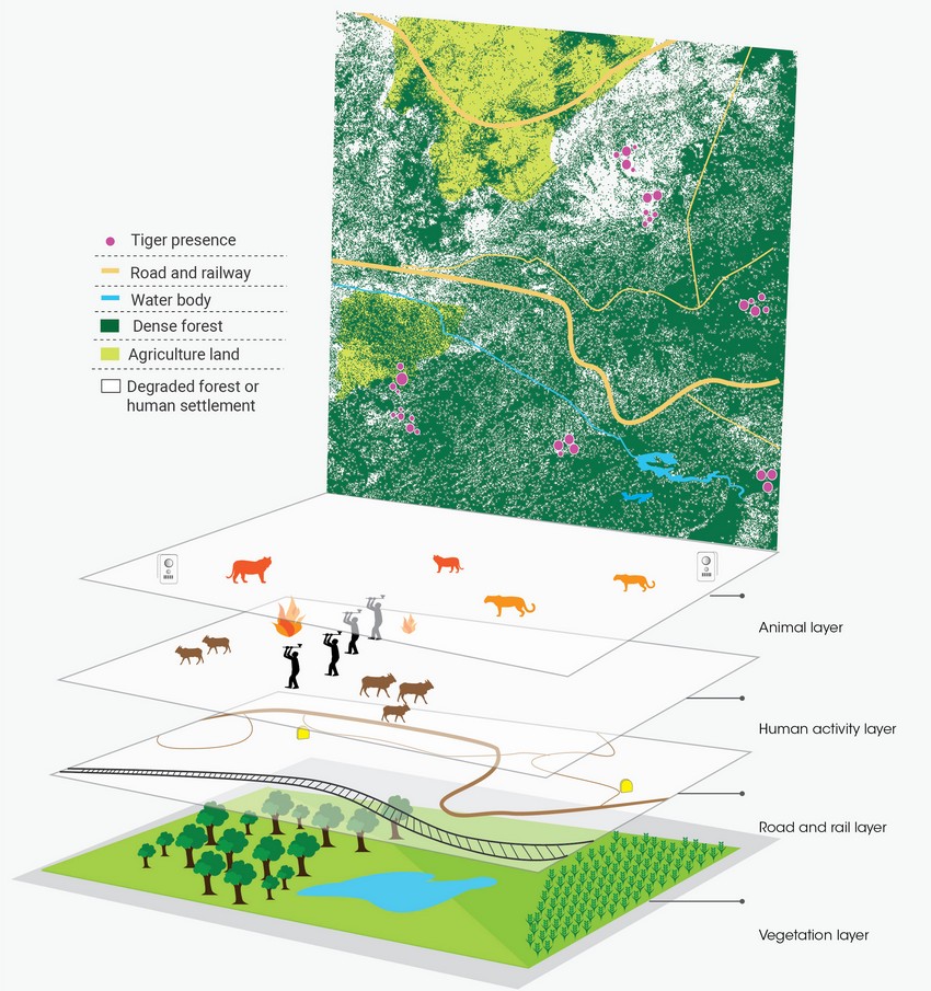
Multiple layers of data are integrated using GIS software to create a composite, landscape-level perspective
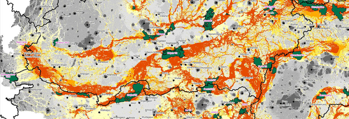
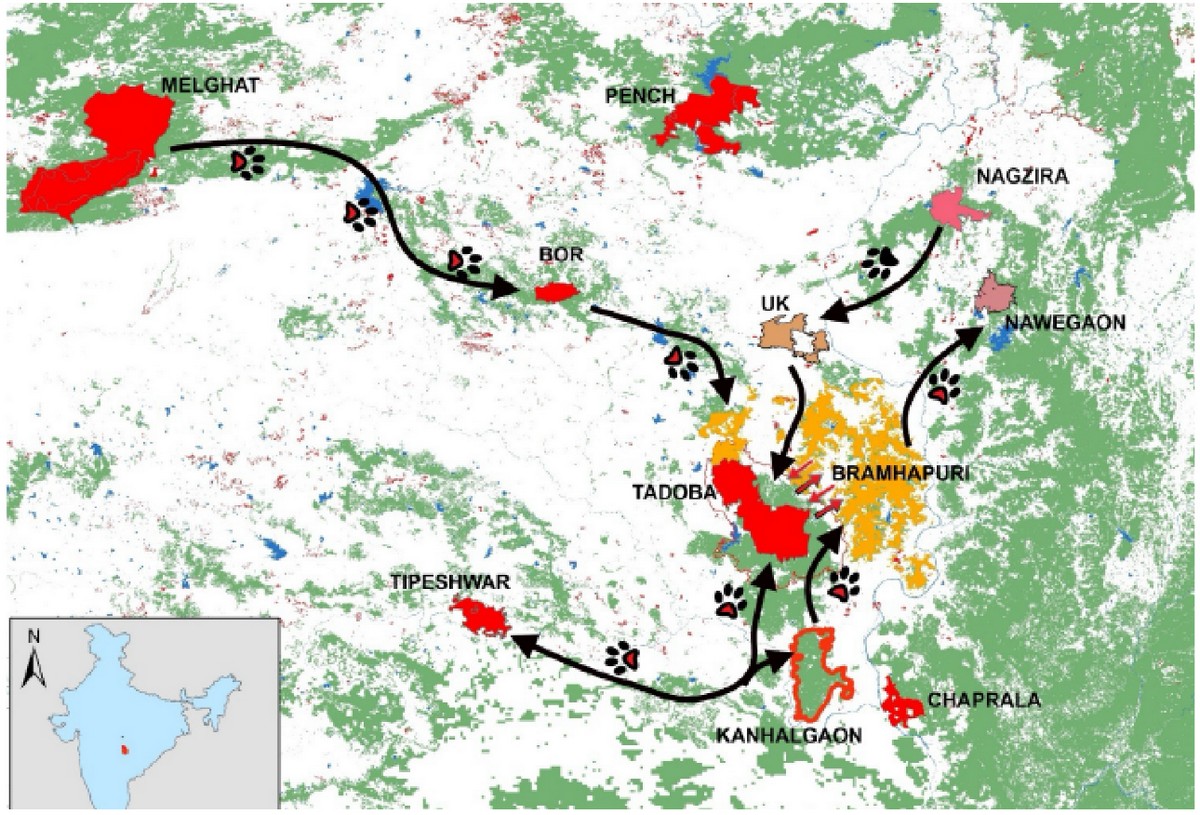
Through a detailed landscape-level analysis and the resulting maps, WCT is able to help the Government better understand wildlife corridors that connect existing PAs and other tiger source sites. The maps show areas best suited for movement of tigers and help identify pinch-points (priority sites) along them. They also highlight areas where there is a break in connectivity. Such areas need urgent attention and protection to ensure long-term sustenance of biodiversity.
Map depicting tiger connectivity between Protected Areas in the Central Indian Landscape
Mitigating the Impact of Linear Infrastructure
India’s fast-growing economy creates a steep demand for linear infrastructure such as roads, railways, power lines and canals. Linear infrastructure may require relatively small portions of forest land, but has a disproportionately large impact on wildlife, in the form of breakages in wildlife corridors, habitat fragmentation, and wildlife mortality (roadkills).
To mitigate the negative impact of such large scale development is beyond the capacity of a single organisation. The problem is compounded by inadequacy of data and lack of capacity among regulatory agencies.
WCT’s Road Ecology programme is designed to create pathways to tackle these problems through an intensive three-pronged approach, which includes the following:
- Surveys: WCT conducts ecological studies on roads which are proposed for expansion, to locate the hotpots of animal movement and help identify suitable locations for introducing mitigation structures, so that conservation costs are set aside at the inception of the project.
- Gaps Analysis: WCT maintains a database of proposed roads and railways that are planned for upgradation. The proposed alignments of these roads and railways are overlaid on maps of existing forests using GIS techniques to identify corridors that are likely to get fragmented. These composite maps are shared with regulatory bodies so that mitigation structures can be planned proactively.
- Capacity Building: WCT collaborates with leading experts to conduct workshops focused on the science and policy aspects of road ecology. We invite practitioners from regulatory agencies such as the NTCA, Forest Department, infrastructure development agencies, NGOs, and wildlife biologists, not only from India but also from other tiger range countries, for these workshops.
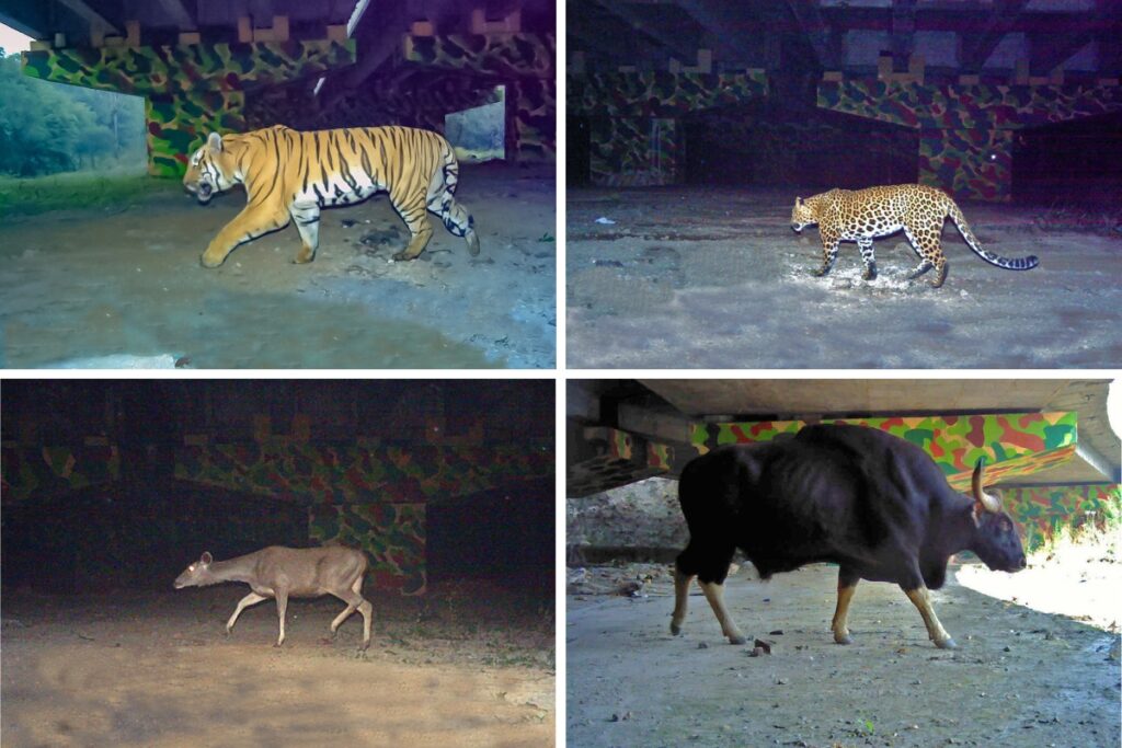
Camera trap photographs of a variety of large mammals using the underpass built on National Highway 44 along the Kanha-Pench corridor (Clockwise from top: tiger, leopard, gaur and sambar).
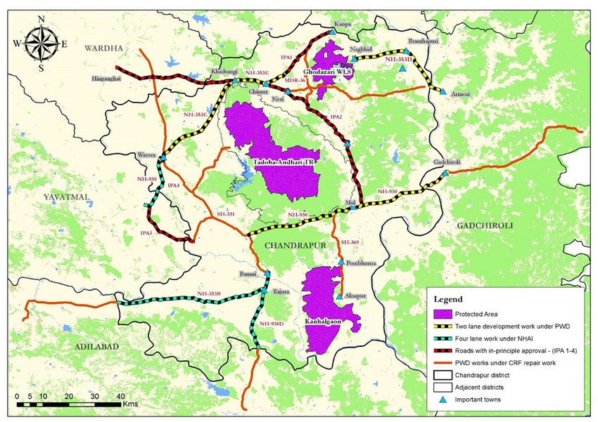
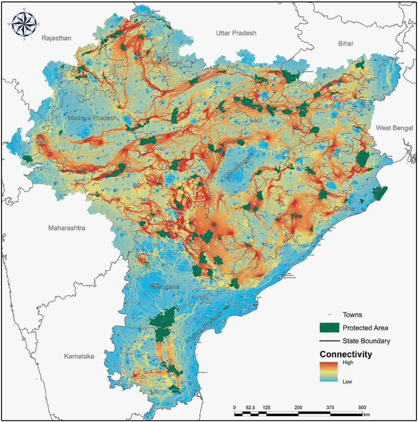
A map depicting existing and proposed roads fragmenting wildlife corridors in Central India
Facilitating Corridor Connectivity using Technology-based Solutions (FACCTS)
Over the last decade, linear infrastructure development has emerged as a major threat to the demographic viability of tigers in India. Development activities such as the upgradation of roads and railway lines lead to animal deaths and hamper the movement of wildlife within and between forest patches. Technology-based monitoring of wildlife movement along the existing roads/railway lines/canals can provide a crucial baseline to place mitigation structures according to the guidelines set by the government. Tech-based solutions also help to minimise wildlife and human mortality caused due to accidents on roads and railway lines passing through wildlife habitats.
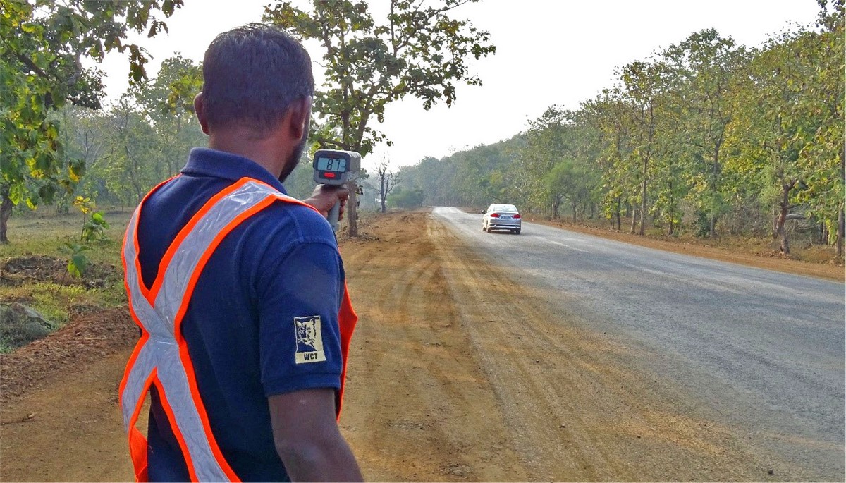
WCT team member collecting traffic speed data with a radar gun. ©WCT
WCT’s FACCTS project is focused on applying existing technology as well as developing new ones to address lacunae in the linear mitigation guidelines for road, and to minimise wildlife/human mortalities and monitor wildlife movement along existing railway lines where structural modifications are not possible.
WCT is carrying out intensive camera trap surveys along various roads and railway lines along critical corridors in the Central Indian Landscape (CIL) including the Kanha-Pench Corridor, Satpura-Melghat Corridor, Tadoba-Kawal-Indravati Corridor and Bandhavgarh-Achanakmar Corridor. The camera trap surveys are helping to obtain fine-scale data on animal presence and movement along the roads that are scheduled to be upgraded.
WCT is gathering baseline data and is providing the Forest Department with information on high priority sites where mitigation structures are required.
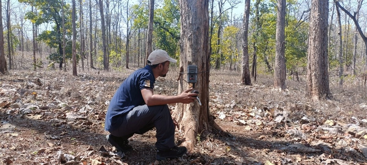
WCT conducts camera-trap based surveys in critical wildlife corridors to identify high priority sites where mitigation structures are required. ©WCT
WCT is also developing and testing new technology to both minimise wildlife mortalities and monitor wildlife movement along existing railway lines passing through wildlife habitats.
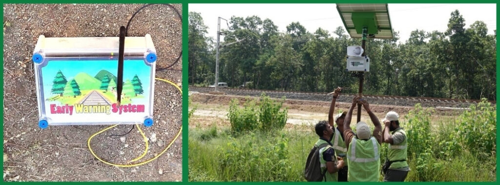
Early warning systems being tested on railway line. ©WCT
Understanding Tiger Dispersal Using Genetics
“Most wild tigers live in small, isolated Protected Areas (PAs). While significant effort has been invested in increasing tiger populations inside PAs, much less has been done to understand the influence of different landscape elements on the connectivity of disjointed tiger populations. WCT is trying to fill this gap by employing genetic approaches in conjunction with landscape ecology to study and measure the extent of such effects on tiger populations.”
Aditya Joshi
Head, Conservation Research
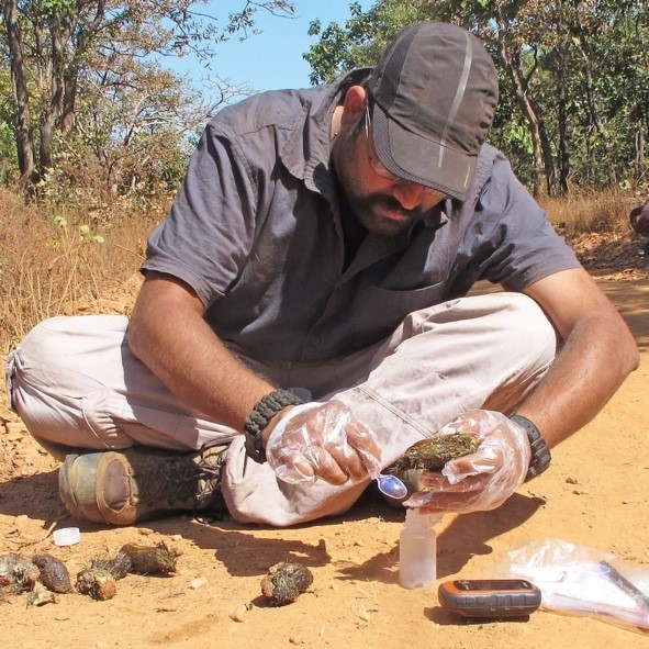
The use of genetics to identify individual animals within a population marks the turning point in wildlife research. WCT’s wildlife biologists have been using this method to unambiguously identify individual tigers from their faeces.
The tiger faecal samples collected from the field are analysed to understand the prey composition of tigers outside protected areas and also the movement of individual tigers across large landscapes. Our research has shown that relatively small PAs and highly fragmented forest patches outside these PAs play an important role in maintaining genetic connectivity between tiger populations interspersed across large human-dominated landscapes.
WCT deciphered important functional tiger corridors connecting Tadoba-Andhari Tiger Reserve with other PAs using DNA extracted from tiger scat samples. ©WCT
WCT’s intensive genetic studies have provided substantial evidence for the need to safeguard corridors for the long-term survival of tigers and their prey.
Radio Telemetry
Being saturated, the core zones of several tiger reserves have no room for young tigers. As a result, a large majority of young tigers disperse into less-protected PAs via corridors.
WCT uses radio-telemetry to understand how dispersing tigers use their habitat, to suggest and implement community interventions for mitigating conflict arising from the interaction between people and tigers.
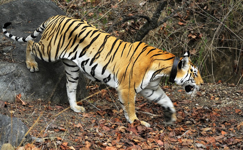
A radio- collared tiger ©WCT
Understanding the dispersal of tigers and leopards also helps us in devising training programmes for frontline forest staff. We also assist the forest department in radio-collaring tigers that have been declared as dangerous to humans, so that, by closely monitoring their movements, we can provide unbiased evidence to guide the forest department in making critical and timely interventions.

Radio telemetry paraphernalia ©WCT
Your donations support our on-ground operations, helping us meet our conservation goals.
Related Links
- Human Wildlife Interface Management
- Livelihood
- World Wildlife Day 2019 – Life Below Water
- Conservation Strategy
- Catalysing Conservation
Header image © Wildlife Conservation Trust